2022年6月29日2時48分50秒ごろ、関東地方で火球の観測報告がありました。 (参考 SonotaCo Network Japan) 我々は地震計のデータを利用して、音波が地上に到達した時刻を調べました。
図1に示すように、衝撃波の信号は山梨県、静岡県、神奈川県の広い範囲にかけて観測されています。 到達時刻が最も早いのは神奈川県の愛川観測点で、2時51分15秒前後です。
隕石は南西から北東へ移動したことが分かりました。 隕石の軌道を延長して地表と交差したとすると、交差点は東京湾の北西側に決まりました。
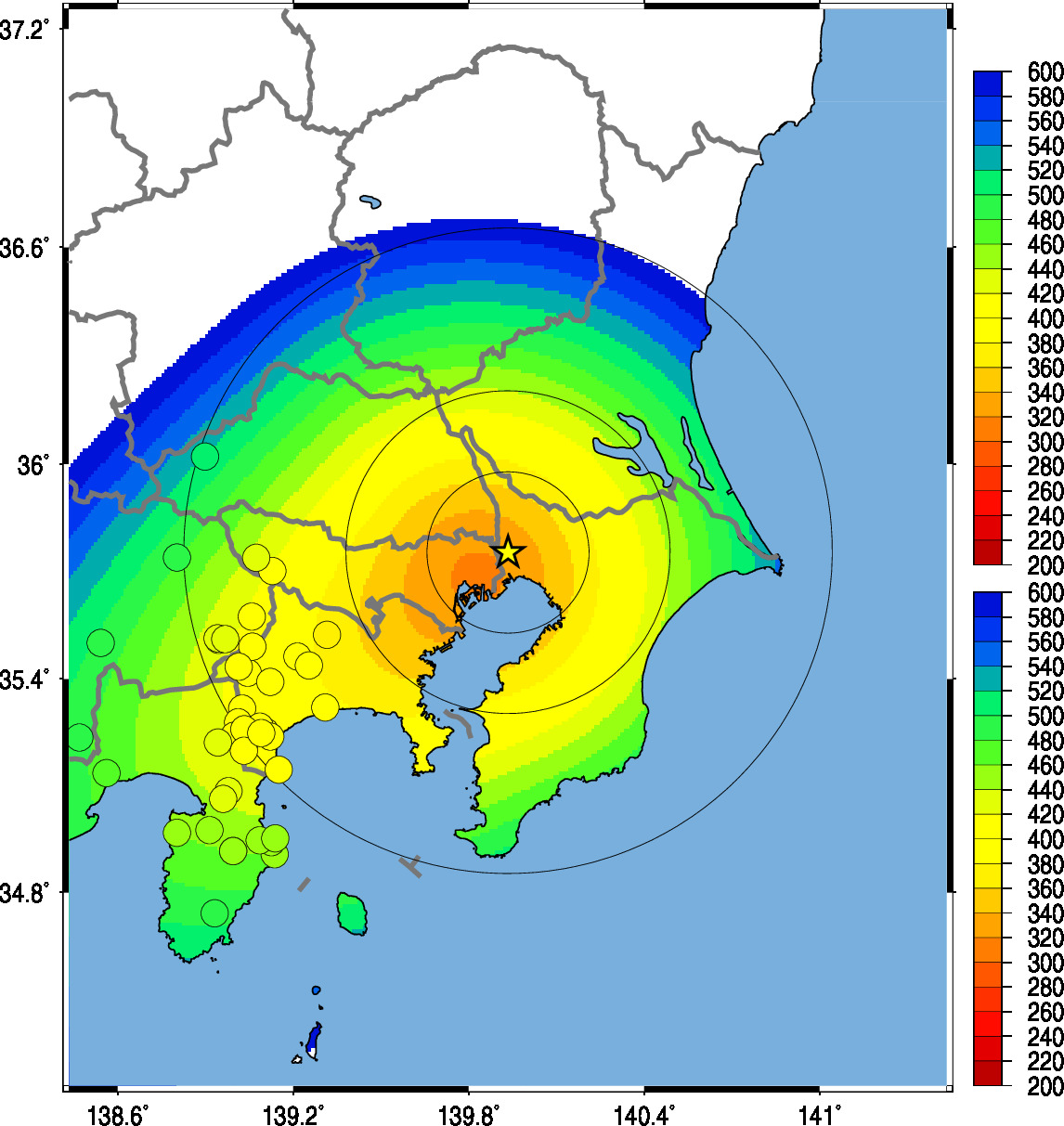
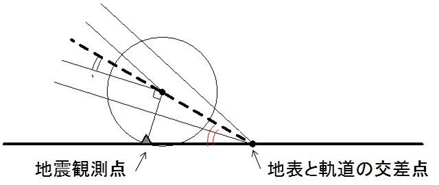
図1 地震計に記録された衝撃波の到達時刻と、到達時刻を説明する線震源モデル
(時間は2時45分からの秒数)
(背景の色が衝撃波の到達時刻を最もよく説明するモデル)。
隕石の軌道の消失点は北緯35.75度、東経139.93度(星印)。
地表と軌道の間の仰角は24度、軌道の方位角は237度(南西から北東へ移動)。
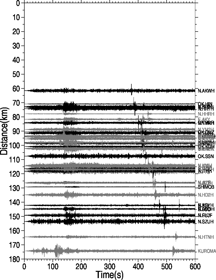
図2 2-8Hzのフィルタをかけた地震波形。(時間は2時45分からの秒数)
地表と軌道の交点から距離の順に並べてある。400-500秒あたりの信号が火球の衝撃波
参考文献:
Yamada, M. (2021). Determining the source of the explosive sound heard in Hokkaido, Japan, on April 26, 2021. Journal of Geophysical Research Solid Earth, 126(12), https://doi.org/10.1029/2021JB023076 2021.11. journal pdf
Yamada, M. and J. Mori (2015). Seismic Observations of the Sonic Boom Produced by the Chebarkul Meteorite. 京都大学防災研究所年報, pp.47-52. pdf
Yamada, M. and J. Mori (2012). Trajectory of the August 7, 2010 Biwako Fireball Determined from Seismic Recordings. Earth, Planet and Space, Vol.64-1, pp.27-35. pdf
Ishihara, Y, Tsukada, S, Sakai, S, Hiramatsu, Y, and Furumoto, M. The 1988 Miyako fireball's trajectory determined from shock wave records of a dense seismic array. EPS 55, 2003
Ishihara, Y, Furumoto, M, Sakai, S., and Tsukada, S. The 2003 Kanto large bolide's trajectory determined from shockwaves recorded by a seismic network and images taken by a video camera. Geophysical Research Letters 31(14):L14702, 2004
Kanamori, H., J. Mori, D. Anderson, T. Heaton, Seismic Excitation by the Space Shuttle Columbia Nature, 349, 781-782, 1991.
Mori, J. and H. Kanamori, Estimating trajectories of supersonic objects using arrival times of sonic booms, U.S. Geological Survey Open-File Report 91-48, 15 p., 1991.
長沢工, 三浦勝美, 地震計記録から決定した 1987 年 9 月 11 日の大火球の径路. 東京大学地震研究所彙報. 第62冊第4号, pp. 579-588, 1988
謝辞:
本研究では、防災科学技術研究所、気象庁、全国の大学の地震観測ネットワークによって記録されたデータを利用しました。